
Tackle the first part of this multi-day hinterland adventure.
Suitability
Suitable for walkers with intermediate fitness and endurance.
Highlights
The 58.8km Sunshine Coast Hinterland Great Walk (SCHGW) gives you access to some of the coast's best scenery along with warm subtropical rainforest, tall open eucalypt forest and picturesque waterfalls.
The Walk is made up of 3 sections, namely the Baroon Section of walks, the Mapleton Falls Section and the Mapleton Section (Delica Road entrance).
The Great Walk was constructed with multiple access points to give visitors different walking experiences along the top of the Blackall Range. It meanders through three reserves that link up via sealed paths through hinterland villages, with a quite a few steep sections adding to the sense of challenge and achievement. You can walk the whole track in 3 - 4 days and camp in beautiful settings or do shorter sections as half-day and full-day options.
This fantastic first section of SCHGW is between Baroon Pocket Dam and Kondalilla Falls. In fact (Note: There are shorter walks to both listed in this adventure directory. In fact, the Baroon Pocket Dam Obi Obi Lookout walk is the first 2 km or so of this trail).
This first section of the walk is between Baroon Pocket Dam and Kondalilla Falls and takes approximately half a day.
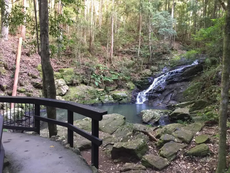
On this section of the Great Walk there are scenic views of mountains and valleys to the west and the Pacific Ocean to the east. Approximately halfway along the walk you come to a wide stretch of the creek where there are great boulders and cliffs to sit while you take a snack break.
The walk takes you on a journey through dense rainforest, with scenic views of mountains and valleys. Approximately halfway along you will come to a wide stretch of the creek where there are great boulders to sit while you take a well-earned rest – or snack break!
There is a fair amount of inclines and descents on this walk, and it is highly recommended you visit the QPWS website for full trail information before setting out. Click link at the top of the page.
Allow a half day one-way and arrange a lift or car shuttle back to your starting point via the road to Montville. The walk could also be done in the opposite direction or as a return journey for extremely fit and experienced walkers.
Take extra care after rainfall, as the track can be very slippery. Phone signal is limited, so make sure you tell someone you are going – a minimum of two people is strongly recommended.
Afterwards
As you near the end of the walk, make sure you have a swim at Kondalilla Falls as you have well and truly earned it. (Carry your swimmers and towel with you)
Near the Kondalilla Falls carpark there is a large grassed picnic area, where there are toilets, picnic tables, barbecues, and shelter sheds – so pack a picnic or BBQ and have in the vehicle you left here. Or head to Montville for your caffeine fix!
How to get there
To the starting point: Travel on the Bruce Highway (M1) and take the Blackall Range tourist drive (23) – actual road is Landsborough Maleny Road. Turn right into Maleny Montville Road which eventually becomes Balmoral Road and then Main Street as you come into Montville. Turn left at Western Avenue and follow this road for about 3 km. Turn left down Narrows Road almost to the end. The Baroon Pocket Dam carpark is off to your right.
To the end point: This is a one-way route. The route ends in the Kondilla Falls carpark, off Kondilla Falls Road. That road joins the Maleny Montville Road on the northside.
About this place
- Suitable for walking
- Dogs prohibited
- Barbeque on site
- Picnic table on site
- Toilets on site
- Walking track grade
- Grade 5
- An unformed track, likely to be very rough, very steep and unmarked. For very experienced bushwalkers with specialised skills.
Graded on the Queensland Parks walking track scale. Walk with care(opens in a new tab)
- Managed by
- Queensland Parks and Wildlife Service
- Sunshine Coast Hinterland Great Walk(opens in a new tab)
To report damage, a hazard or another problem with the trail:
Safety
Hazards on this trail
Many switchbacks, and steps.
Check park alerts before you go
Sunshine Coast Hinterland Great Walk is managed by Queensland Parks and Wildlife Service. Check their park alerts for closures and track conditions. Park alerts in the Sunshine Coast region(opens in a new tab)
In an emergency, call 000. Always adventure safely!
- Always follow any local signage, it contains key information and conditions can change at any time.
- Use the trails with consideration for your abilities, be prepared for the adventure ahead:
- Be aware of the weather conditions, found here: Bureau of Meteorology — Queensland(opens in a new tab)
- Always wear appropriate clothing, focus on good footwear.
- Always bring more water than you think you will need.
- Be Sun Safe!
- Always let someone know where you are going that isn't going with you.
- Just getting started try this site for good useful information: Trail Hiking Australia — hike safety(opens in a new tab)
- Sunshine Coast Council does its best to keep this information current, but things change, so be aware that a trail may not be as listed here.
This section of the Great Walk is one of the best walks on the coast in my opinion. It has something for everyone from short walks to some great lookouts to full day hikes as part of the Great Walk, plenty of parking, relatively easy and close to a range of great cafes in Montville. Worth visiting this section to get to the Narrows lookout - about a 15 min walk in.
Nearby trails

Your Adventure Starts Here
Save favourites, plan trips, earn badges and share your trail photos with the community — free, in seconds.
Always free · Sign up in seconds
Printed from Adventure Sunshine Coast · https://adventures.sunshinecoast.qld.gov.au/trails/24820/sunshine-coast-hinterland-great-walk-baroon-section
Always check current conditions and closures before you set out.